Interessent(inn)en aus 25 europäischen Ländern meldeten sich auf der Website des ESA-Ideenwettbewerbs Copernicus Masters an, fast 70 Arbeiten wurden bis Ende Juni eingereicht. Eine Jury aus Vertretern der GEO-Redaktion, der ESA und des Bayerischen Wirtschaftsministeriums, Schirmherr des Copernicus Masters, ermittelte aus den zugesandten Arbeiten die 20 besten fürs Finale. Aus diesen 20 sollen nun per Publikumsabstimmung jene zwölf ausgewählt werden, die von der ESA als exklusiver Kalender herausgegeben werden. Die drei bestplatzierten Arbeiten werden zudem in den Europa-Ausgaben von GEO erscheinen.
Der Gewinner der GEO Illustration Challenge wird im Rahmen einer feierlichen Preisverleihung am 5. November 2013 in München bekanntgegeben. Als ersten Preis hat GEO einen Illustrationsauftrag für eine Magazin-Geschichte ausgelobt, außerdem eine Reise zum Launch eines ESA-Satelliten auf dem europäischen Raketenstartplatz in Französisch-Guayana.
Und nun sind Sie an der Reihe. Bis zum 18. August 2013 haben Sie hier die Möglichkeit, pro Illustration bis zu fünf Punkte zu vergeben. Bitte beachten Sie, dass Sie für jedes Bild nur einmal abstimmen dürfen! Zur besseren Orientierung haben wir den Arbeiten die Titel und die Erläuterungen der Künstler(innen) beigefügt.
Als zusätzlichen Anreiz verlosen wir unter allen Usern, die sich an der Abstimmung beteiligen, ein kostenloses GEO-Jahresabo (in D, A und CH inklusive iPad-Version und GEOcard).
Und nun wünschen wir Ihnen viel Spaß bei der Punktevergabe.
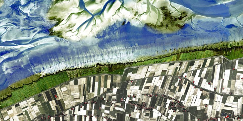
The satellite image shows the current coastline andWadden Sea in Warffum, Netherlands. In this picture it's very easy to see
the different steps of human intervention and to anticipate the coming developments and what
the future landscape and land use will look like. Here the natural complex and floating forms of the North Sea contrast with
the orthogonal and rational human structures. The archetypal wild Wadden Sea is slowly being transformed into a saltmarsh. The rectangularshaped bed structure is even visible within the water. Different shades of green indicate the different levels of development. The ongoing fight between nature and humankind is visible and perceivable. The first dyke-line forms a sharp and distinct cut into this landscape. The polder fields south of the dyke are used for agriculture and are built by rational parameters. Humankind conquers
and domesticates nature.
Behind the second dyke-line, orthogonal and rational textures define the polder-landscape. Farms and small villages
assemble and grow quickly. The inverse illustration (intensive colors for the natural sea and low intensity of color for the human formed structures) offers the possibility to play the guessing game of how the Wadden Sea in Warffum has looked
in the past, how it will be transformed and what it will look like in future.
VOTE FOR YOUR FAVOURITE ILLUSTRATION - AND WIN
Voting has commenced to pick 12 from 20 finalists
The pan-European Illustration Challenge organised by GEO and the European Space Agency is in its final round. In February, GEO put out a call for satellite images of the earth which use artistic methods or graphic design to expose the "Traces of Humankind".
Contenders from 25 European nations registered via the website of the ESA's Copernicus Masters ideas contest, and almost 70 compositions were entered by the end of June. A jury of representatives from GEO, the ESA and the Bavarian Ministry of Economics, alongside the patron of Copernicus Masters, chose the 20 best entries to go on to the final. The 12 images selected by the public are to be published in an exclusive calendar by the ESA. In addition, the three highest-ranking works will appear in the European editions of GEO.
The winner of the GEO Illustration Challenge will be announced at a celebratory prize-giving on November 5th 2013 in Munich. The award for first-prize will be an illustration assignment for a magazine story, as well as a trip to the launch of an ESA satellite at the rocket launch-site in French Guiana.
Now it's up to you. At www.geo.de or www.copernicus-masters.com vote for your favourite illustration by August 18th and rate the illustrations on a scale of one to five. Please note that you can only vote for each image once! The title of each work and an artist's commentary are available for guidance.
As an additional incentive, all users who take part in the vote will be entered into a prize draw to win a free year's subscription to GEO. (In Germany, Austria and Switzerland this includes an iPad version and a GEOcard.)
Happy voting!


